
I am a firm believer in the value of Unmanned Aircraft Systems (UAS), commonly called drones. Perhaps you would expect nothing less from a former US Air Force pilot and current drone owner, but I don’t think my enthusiasm is misplaced. During my 35 years in the telecommunications industry, I developed a bit of skepticism for technology fads — I have seen my fair share of new technology that overpromised and underdelivered. However, UAS are already proving their mettle in several areas:
Inspections — The April 2017 ISE magazine article "The New Frontier: Drones" outlined the safety and cost benefits tower owners are already realizing by using UAS for tower inspection and space assessment for new antennas. These tasks previously required climbing towers — dangerous work. UAS can capture more information, faster and at a lower cost. At the 2017 Esri GeoConX Conference in Chicago, companies showed drones flying close to power lines to auto-identify broken insulators and other hazards. (See Figure 1.)
Figure 1. Site Inspection.
Site Evaluation — This application, which offers even greater potential, is for surveying and evaluating new wireless antenna sites. With aggressive plans to offer new 5G wireless services, companies need to build thousands of new macro sites to augment the more than 100 K towers that already exist in the United States. UAS can map and collect site data faster and at a much lower cost than manual field collection. Using high-resolution imagery and LIDAR, UAS can perform site surveys.
Virtualization — GIS technology has always been useful for producing maps that show existing network capabilities, bandwidth capacity, and new market opportunities. It is a valuable tool for initial site analysis when companies are looking to place new cell towers. Properly equipped UAS perform detailed measurements for final site evaluation. Drones equipped with HD video and LIDAR can provide unparalleled imagery and detailed point cloud measurements that can exceed what was previously available through manual methods.
UAS can access locations and provide unique views that are not possible from traditional ground-based observation approaches. Data collection is easier than ever, with preprogrammed flight paths that ensure complete coverage and data accuracy for even the most remote locations. (See Figure 2.)
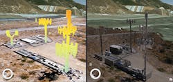
Figure 2. Integration of LIDAR and HD Imagery.
Data Processing — Post processing the data is becoming quicker and easier with direct integration into GIS and mapping systems. It is possible to review data while in the field, ensuring that you have collected all that you need. Back in the office, you can create terrain and surface models or use point clouds and meshes to create 3D views. Engineers can later fly the sites virtually, saving time and costly field visits.

About the Author