How Does Your 5G Site-Candidate Interview?
Telecom Solutions: Learn How Software-Assisted Mobile Site Acquisition Can Vet Your Candidates the Right Way
As data consumption surges, mobile network operators (MNOs) are tasked with increasing network bandwidth and capacity. To achieve this, 5G deployments must be accelerated. Rolling out new 5G radio access networks (RANs) will give networks the additional bandwidth needed to transmit massive amounts of data with minimal latency. Yet, they also add to the demands of the backbone network infrastructure.
Since 5G radio doesn’t broadcast as far as older 4G versions, many more sites are needed to fill in coverage gaps. These sites include the entire set of equipment needed to receive and transmit radio signals for cellular services, as well as equipment to process these signals. A typical cell site will include antenna systems, RF units, power amplifiers, combiners, filters, a baseband unit (BBU), a power supply, and network interface modules.
“After a site candidate is selected, the planning and procurement of site assets can begin. Due to their complexity, these assets need highly sophisticated rollout management. After all, there will be hundreds, if not thousands, of configuration parameters per site, per technology.”
Keep in mind, there is a rigorous selection and build process behind each cell site, and only one candidate out of multiple alternatives will be considered for build. The types of sites needed within the network vary greatly, from small cells to distributed antenna systems (DAS) to macro towers. Every site candidate must be evaluated to ensure it is fit for the purpose. For example, towers may have to adhere to height restrictions while small cells, which operate at higher frequencies, are subject to strong emitting power limitations. Additionally, every potential site must tick multiple checkboxes before the design and build can even start. Approval from local authorities—in the form of environmental, safety, and building permits—is an absolute precondition.
As project managers research locations, factors including the line of sight to users, access to power supply and a backbone transport network (or wireless line of sight), and contract terms with the property owner, all must be considered. When multiplied by the tens of thousands of sites that a 5G mobile network needs, the complexity of mobile site acquisition increases.
Utilizing Software to Support RAN Rollout Processes
Data pertaining to the possible sites must be collected in an organized manner and stored in a central location so that all candidate information can be easily accessed, shared, and evaluated. After a site candidate is selected, the planning and procurement of site assets can begin. Due to their complexity, these assets need highly sophisticated rollout management. After all, there will be hundreds, if not thousands, of configuration parameters per site, per technology.
Fortunately, software solutions can make it easier to find, plan, and document all facets of the RAN rollout process. Features that will yield the biggest benefits include one central database, GIS-based location intelligence, analytics, and an information bank.
A Central Database
Rollout project managers must know exactly which sites are available and have access to detailed information about them. A solution that provides a verified inventory of all sites, their infrastructure assets, active equipment, cabling, power, cooling, and configurations is business critical.
All physical, logical, and virtual resources, along with acquisition data, should be stored within a central database and managed holistically. This will give project managers a complete view that can assist with decision-making and enable network engineers to concentrate on planning the new backhaul links, POPs, and edge data centers—all using the same database. Three components of this database can also serve as a digital twin of the network.
1. Geographic Information System (GIS). A combination of GIS-based location intelligence and network infrastructure details can streamline site selection and management.
A solution that integrates GIS-based location intelligence with a digital twin of the network takes site management to another level by enabling users to visualize sites and site candidates on maps and analyze information about site acquisition status. With the right solution, POPs, along with RAN, can be viewed on the same map.
The combination of location intelligence with site data, site equipment, and network infrastructure details enables planners to streamline the fiber and microwave deployments needed to connect sites.
2. Accurate Reporting and Analytics. Configurable reports that provide real-time data can help MNOs determine if a site meets certain criteria. Making these determinations is more efficient and accurate when aided by interactive dashboards that analyze theoretical sites and candidates with their relations. These dashboards can take care of the heavy lifting and deliver reliable, objective answers to the evaluator’s most pressing questions.
3. “Friendly Site” Information Bank. As new sites can be added to the network at any time, site information should always be retained. Look for a solution that can store information collected about sites that were not selected and make it available for later profiling and rating. Real estate and facility documentation should be stored within its content management system, similar to how technical information about infrastructure assets and resources is documented.
Site Selection Made Easy
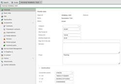
Overall, site selection is a complicated process that can be made easier with software. One example is FNT Command. Figure 1 illustrates how software can be used for the planning and storing of site candidates.
Before any work can begin, a nominal site must first be created in the software. A nominal site represents the search area for a future site. It must be supplied with its geo-coordinates and a search radius.
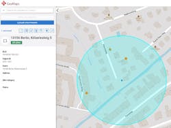
Assuming that the “friendly sites” were populated into the software’s database independently from nominals, you can now search for the best site candidate. The ideal software will perform a radius search of a nominal, which will yield candidate sites, which are your buildings, poles, and existing partner sites. (See Figure 2.)
Each candidate can then be supplied with a variety of additional information needed for profiling and rating. Such information includes existing contractual relations with owners and site sharing information.
Based on the best match to certain criteria, one site candidate will be selected for further development. At this point, a physical location can be linked, and the user can drill down to the details of the sites.
With a software solution that supports the integrated management of telecommunication infrastructures, IT assets, and data centers, all necessary information will be available to streamline site selection processes.
About the Author
Daria Batrakova
Director, Business Line Telecom Solutions, FNT Software
Daria Batrakova is Director, Business Line Telecom Solutions at FNT Software. She has worked in network operation, OSS integration and solution advisory roles in the telecommunications field for almost 20 years. Daria graduated from Moscow State University with a bachelor’s degree in applied mathematics. For more information, email [email protected] or visit https://www.fntsoftware.com/en. Follow Daria on LinkedIn: https://www.linkedin.com/in/dariabatrakova/. Follow FNT Software on Twitter: https://twitter.com/FNTsoftware, and LinkedIn: https://www.linkedin.com/company/fnt-software/.


